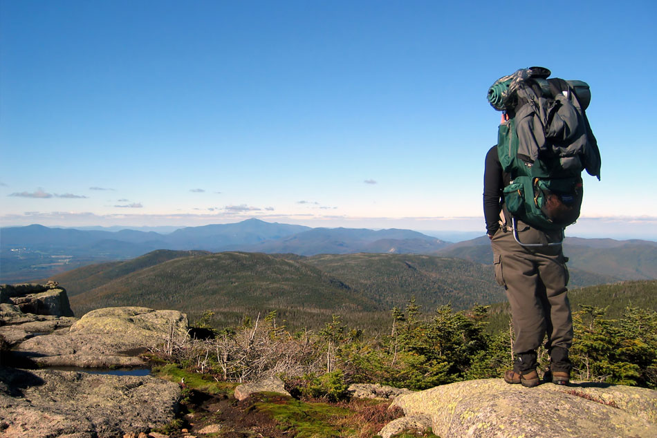
Tuolomne Meadows
Yosemite, CA – Tuolumne Meadows serves as a hub for summer backpacking opportunities in the park. Temperatures average 15 to 20 degrees Fahrenheit cooler than in Yosemite Valley, and, at 8,600 feet in elevation, the air is crisp, invigorating, and thin! Tuolumne hikers enjoy a variety of popular routes and many of the trailheads are within a short distance of each other. Trails range from just a few miles to Sunrise Lakes to thousands of miles on the Pacific Crest Trail. Remember, any blue sky day can quickly turn ominous and gray. The Sierra are well known for their magnificent afternoon thundershowers; enjoy these from a safe location in good rain gear. (The Tioga Road closes due to snow, usually from sometime in November through late May or early June. There is no overnight parking on the Tioga Road after October 15, please plan accordingly.)
Trailhead Information Trailhead Descriptions Descriptions and Mileage
Hike to the top of Half Dome
Yosemite, CA – The 14- to 16-mile round-trip hike to Half Dome is not for you if you’re out of shape or unprepared. You will be gaining elevation (for a total of 4,800 feet) most of your way to the top of Half Dome. Most would say the reward is worth the effort. Along the way, you’ll see outstanding views of Vernal and Nevada Falls, Liberty Cap, Half Dome, and–from the shoulder and summit–panoramic views of Yosemite Valley and the High Sierra.
Butano State Park
between Santa Cruz and Half Moon Bay – A 2,200-acre redwood park in the Santa Cruz Mountains, featuring excellent hiking through the redwood groves. Only three miles from the Pacific coast, the park’s trails offer views of the Pacific Ocean and the Año Nuevo islands.
Florence Lake / Lake Thomas Edison (Evolution Valley)
Sierra National Forest – Lake Thomas Edison – Edison Lake is surrounded by the John Muir and Ansel Adams Wildernesses. One-mile east of the Lake are the popular John Muir and Pacific Crest hiking trails. Wilderness permits are required for overnight stay. Shuttle Service is provided by the Vermillion Valley Resort for hikers who wish to cross the lake and start their journey into the wilderness at the east end of lake.
Florence Lake – Four miles east of the lake hikers and equestrian users can connect to the popular Pacific Crest Trail in the John Muir Wilderness. Permits are required for overnight stay. Ferry service is available for hikers who wish to cross the lake by boat.
Horseback riding and guided pack services are available nearby.
South Sister Peak
29 miles west of Bend, Oregon – About the Hike: Oregon’s third-tallest mountain has a path to its top. Admittedly, the trail up 10,358-foot South Sister is exceedingly steep, long and rugged, but no technical climbing skills are required and the rewards are great.
The Desolation Wilderness
Lake Tahoe, CA – The Desolation Wilderness is made up of 63,960 acres of subalpine and alpine forest, granite peaks, and glacially-formed valleys and lakes. Located west of Lake Tahoe and north of Highway 50 in El Dorado County, the Desolation Wilderness is jointly administered by both the Eldorado National Forest and Lake Tahoe Basin Management Unit.
Big Basin Redwoods State Park
Santa Cruz County – Rancho Del Oso, Hwy 1 831-338-8860
Located 25 miles south of Half Moon Bay on Hwy. 1, the park has miles of trails, which serves hikers and equestrians, links Big Basin to Castle Rock State Park and the eastern reaches of the Santa Cruz range.
Julia Pfeiffer Burns California State Park
Big Sur, CA – The park stretches from the Big Sur coastline into nearby 3,000-foot ridges. The park features redwood, tan oak, madrone, chaparral, and an 80-foot waterfall that drops from granite cliffs into the ocean from the Overlook Trail. A panoramic view of the ocean and miles of rugged coastline is available from the higher elevations along the trails east of Highway 1.
The park offers Environmental Camping only. Located west of the highway a little over 1/4 mile from the parking lot, Saddle rock (No 1) and South Garden (No. 2) are the park’s only campsites. Visit their Web site for additional information. More >>
The Tahoe Rim Trail
Lake Tahoe, CA & NV – The Tahoe Rim Trail is one of the world’s premier trails. It passes through two states (California and Nevada), six counties, one state park, three National Forests, and three Wilderness areas. This spectacular trail is 165 miles of single-track multiuse trail, winding peak to peak around Lake Tahoe. It is a trail that offers something for everyone! Hiking and horseback riding are allowed on all portions of the trail, while mountain biking is allowed on the trail with the exception of the wilderness areas, the section that is in the Lake Tahoe Nevada State Park, and on the sections of trail that overlap with the Pacific Crest Trail.


